New LPA spotted as ‘Hanna’ further intensifies – Pagasa
Credit to Author: kadraneda| Date: Mon, 05 Aug 2019 05:13:38 +0000
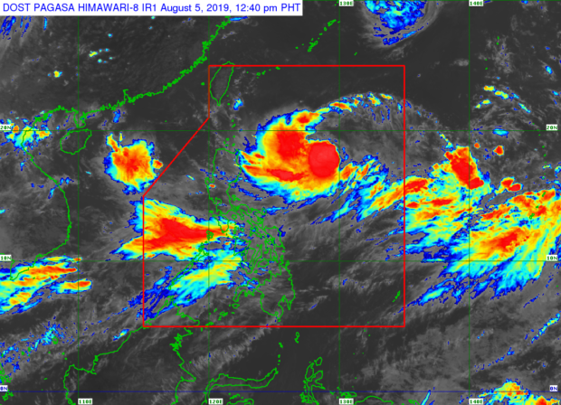
MANILA, Philippines — The state weather bureau is monitoring a new low pressure area (LPA) over the West Philippine Sea.
The latest LPA, however, is still unlikely to develop into a tropical depression, said Benison Estareja, weather specialist of the Philippine Atmospheric, Geophysical and Astronomical Services Administration (Pagasa), midday Monday.
Nevertheless, he also said, the new LPA has pulled the winds of the southwest monsoon away from Luzon, which was why rains in Metro Manila and some parts of the region were not heavy as expected.
“Kung mapapansin ninyo, sa kanlurang bahagi ng Luzon ay may habagat pero in this case nada-divert ‘yung hangin; imbes na tumagos sa bandang Luzon ay napupunta sa LPA,” Estareja explained.
“Kaya medyo maaraw ngayon sa Metro Manila, Central Luzon, Calabarzon. ‘Yung habagat ay nasa may Mimaropa and Western Visayas,” he added.
Meanwhile, Pagasa said Tropical Storm Hanna (international name: Lekima) slightly strengthened as it continued to head closer towards Northern Luzon. It is expected to intensify into a severe tropical storm within 24 hours.
Hanna packed maximum sustained winds of 85 kilometers per hour (kph) near the center and gusts of up to 105 kph. It was moving at 15 kph west northwest, the state weather bureau noted.
Because of this, moderate to heavy monsoon rains will be experienced over the northern portion of Palawan (including Calamian and Cuyo Islands), Mindoro Provinces, Romblon, and Western Visayasm Pagasa said. /kga
Click here for more weather related news.”