This Week in History: 1949: The Hope-Princeton Highway opens
Credit to Author: John Mackie| Date: Fri, 01 Nov 2019 23:50:35 +0000
In August, 1860 colonial B.C. Governor James Douglas visited Fort Hope, then a jumping-off point to the Cariboo gold fields.
Douglas gave a speech where he proposed to make Hope the head of steamship navigation on the Fraser River. He intimidated that he also wanted to build two roads to the interior from Hope, one north up the Fraser Canyon, the other east to the Similkameen Valley.
To help pay for it, Douglas proposed a one-cent-per-pound toll on freight as it passed Hope. But this didn’t please Hope political leader Donald Chisholm.
“(Chisholm) replied to the Governor’s remarks in a most injudicious and impolitic way,” wrote R.E. Gosnell in the Aug. 22, 1908 Daily Province. “They wanted, he said, the privileges of a free country in every manner, shape and form, a free people, free roads and freedom from taxation.”
Representatives from Yale told Douglas they had no problem collecting a toll. So Yale was named the head of navigation, and got the road. And the southern road to the Similkameen fell by the wayside.
It wouldn’t get built for another 89 years. But on Nov. 2, 1949, Premier Byron “Boss” Johnson placed a key in a padlock and opened the Hope-Princeton Highway.
“As the padlock sprang open in the Premier’s hands, he declared the $12 million Hope-Princeton Highway officially open,” The Vancouver Sun reported. “Cars drove over the new stretch of blacktop highway which will lop 100 miles off the distance from the South Okanagan to Vancouver. The road, conceived more than 100 years ago, is the last link in the 713-mile highway which stretches across the province.”
Map in the Vancouver Province on Nov. 2, 1949, showing the Hope-Princeton Highway and how it connected to other roads to form a southern route to Alberta. The route is now Hwy. 3.
That would be the southern route from Vancouver to the Alberta border, a scenic route that snakes through the Similkameen to the Okanagan, the Kootenays and the Rockies.
The Province ran a map of the southern highway, which wasn’t all blacktop — stretches between Osoyoos and Bridesville, and Grand Forks and Trail, still appear to have been gravel.
But that didn’t damper the enthusiasm of 6,000 “highway enthusiasts” who turned out for the opening of the highway at the summit of Alison Pass, the highest point on the Hope-Princeton.
The first person past the barrier was 81-year-old Charles Bonnevier, who The Province described as “a grizzled old prospector with an ancient black hat, a faded mackinaw and a beard that matches his profession.”
“Since he first started prospecting in the hills back of Hope in 1895, Charles Bonnevier had crossed and recrossed the timbered summit on foot countless times in his search for precious metals,” wrote The Province’s Gordon Root.
“I’ve been waiting for this road 54 years,” he told Premier Johnson.
The province had been looking at building the Hope-Princeton since 1930, when it sent a survey crew to map out a route, and built a “work road” for heavy machinery. But finances were too tight during the Depression for the highway to be completed.
Ad for the opening of the Hope-Princeton Highway in the Nov. 3, 1949 Vancouver Sun.
The idea was resurrected in 1945, when the estimated cost was $2.75 million. But building a highway through the mountains proved to be far more difficult than anticipated — the final cost was over four times the 1945 estimate.
Building the Hope-Princeton was also quite deadly — five workers were killed during the construction. Sadly, three people were killed in a car accident the day the highway opened after their car went off the road and plunged 50 metres down a mountainside.
The province took out full-page ads in Vancouver’s papers for several days to tout the new highway and towns along the route.
“Hope is now the gateway from the west, as Princeton is at the eastern end, to a scenic grandeur unrivalled in this province — through the valleys of the Small and Skagit Rivers and the route through Alison Pass,” says one ad.
“Manning Park, one of the most scenic of all our provincial parks, reveals itself in all its impressive grandeur.”
In case you’re wondering, Manning Park is named after B.C.’s former chief forester Ernest C. Manning, not the Ernest C. Manning who was the long-time Social Credit Premier of Alberta.
In 1949, B.C.’s provincial government was a coalition of Liberals and Conservatives. A Vancouver Sun editorial suggested that the new highway should be named after Herbert Anscomb, who was public works minister when work on the highway was finally begun.
But Anscomb was a Conservative, and Premier Johnson a Liberal, so Johnson declined to name it after his cabinet colleague. Which is how it became the Hope-Princeton Highway.
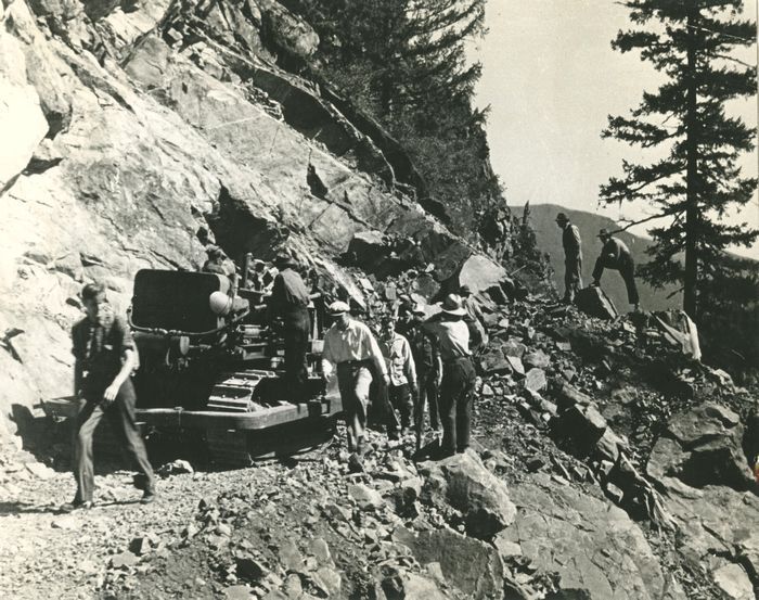
The path for the Hope-Princeton Highway after it was cleared through the forest and bush, late 1940s. This would have been done first, a road crew would have then laid down blacktop. An editor has written a map of the route onto the print, which originally ran with another pic on the bottom. Province files.
The bottom photo.
The crowd at the opening ceremony for the Hope-Princeton Highway at Allison Pass on Nov. 2, 1949. Artray/Vancouver Sun archives.
An “Evergreen Arch” spanned the Hope-Princeton Highway at Allison Pass for the opening ceremony for the road on Nov. 2, 1949. Artray/Vancouver Sun archives.
Ad for the opening of the Hope-Princeton Highway in the Nov. 2, 1949 Vancouver Sun.
Ad for the opening of the Hope-Princeton Highway in the Nov. 4, 1949 Vancouver Sun.
https://vancouversun.com/feed/